

Map Portfolio: North Atlantic Right Whale Satellite Telemetry Research
Now available from University Press of Florida!
Entanglements: The Intertwined Fates of Whales & Fishermen by Tora Johnson
Click on the links to see enlarged maps. High resolution images may take up to a minute to load, depending upon your connection speed.
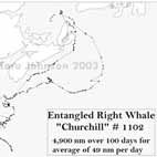
These maps show the movements of endangered North Atlantic right whales which were entangled in fishing gear. Whale rescue teams attached satellite telemetry tags to the gear to help in relocating the animals for rescue. The telemetry tracks are helping us to evaluate regulations and methods in place to prevent entanglement.
Images and content copyright Tora Johnson. All rights reserved. Reproducing and/or distributing this material without permission is forbidden by federal law. Data sources: ESRI ArcAtlas 2001, Massachusetts Office of GIS and Center for Coastal Studies.
Entangled Whale "Churchill" #1102
Southern Portion of Track

Entangled Whale "Churchill" #1102
Full Telemetry Track

Entangled Whale "Calvin" #2223
Telemetry Track w/ Critical Habitat Areas

Entangled Whale "Calvin" #2223
Telemetry Track w/ CHA & SAM

