Map Portfolio: The Union River Watershed of Hancock County, Maine
Click on the links to see enlarged maps. High resolution images may take up to a minute to load, depending upon your connection speed.
Images and content copyright Tora Johnson. All rights reserved. Reproducing and/or distributing this material without permission is forbidden by federal law. Watersheds generated using ESRI ArcMap with Spatial Analyst Extension. Data sources: ESRI ArcAtlas 2001, Maine Office of GIS.
The Union River Watershed

The Card Brook Watershed

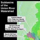
Subbasins of the Union River Watershed